
DOLKA 888LS
BMS DRONES INTRODUCTION
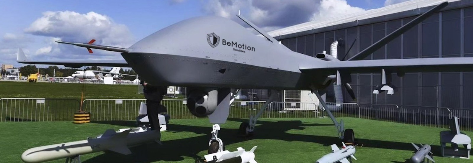
The BMS 888LS is a sophisticated and versatile unmanned aerial vehicle (UAV) designed to meet the diverse needs of modern aerial operations. Known for its durability, advanced technology, and exceptional performance, the BMS 888L is an ideal solution for the government’s military drone program. This UAV is equipped to handle various applications, including surveillance, reconnaissance, agricultural monitoring, environmental assessment, and infrastructure inspection. With its robust design and cutting-edge capabilities, the BMS 888LS promises to enhance operational efficiency and provide valuable insights through its high-quality data collection and analysis features.
General Specifications:
- Model: BMS 888LS
- Type: Fixed-wing drone
- Weight: 300 kg (661 lbs)
- Wingspan: 7.5 meters (24.6 ft)
- Length: 4.6 meters (15.1 ft)
- Material: Advanced composite materials for enhanced durability and lightweight performance
Flight Performance:
- Maximum Flight Time: Up to 10 hours (depending on payload and conditions)
- Range: Up to 250 km (155 miles) with extended-range capabilities
- Maximum Altitude: 5,000 meters (16,404 ft) above sea level
- Cruising Speed: 120-150 km/h (75-93 mph)
- Wind Resistance: Up to 70 km/h (43 mph)
Imaging and Data Collection:
- Camera: High-resolution EO/IR camera for day and night operations
- Payload Capacity: Up to 80 kg (176 lbs) for various sensors and equipment
- Multi-spectral Imaging: Optional multi-spectral camera for agricultural and environmental analysis
- Gimbal: Stabilized gimbal for clear and stable imaging
Navigation and Control:
- Autopilot System: Advanced autopilot with GNSS (GPS/GLONASS/BeiDou) for precise navigation
- Ground Control Station: User-friendly interface with real-time data streaming and mission planning
- Flight Modes: Fully autonomous, semi-autonomous, and manual control options
Communication & Powertain:
- Data Link: Encrypted communication link for secure data transmission
- Control Range: Up to 200 km (124 miles) with line-of-sight
- Engine: Dual-engine configuration for enhanced reliability and performance
- Fuel Capacity: Large fuel tanks for extended endurance missions
- Fuel Type: Aviation-grade fuel for optimal efficiency
Safety and Compliance:
- Obstacle Detection: Equipped with multi-directional obstacle detection sensors
- Failsafe Mechanisms: Automatic return-to-home (RTH), low fuel warning, and emergency landing features
- Regulatory Compliance: Meets international UAV safety and operational standards
Software and Data Management:
- Mission Planning Software: Intuitive software for planning, monitoring, and analyzing missions
- Data Processing: Compatible with leading GIS and photogrammetry software for post-processing
- Cloud Integration: Secure cloud storage options for data management and sharing
Applications:
- Agriculture: Precision agriculture, crop health monitoring, and field mapping
- Environment: Wildlife monitoring, environmental surveys, and habitat analysis
- Infrastructure: Inspection of power lines, pipelines, and construction sites
- Security: Surveillance, reconnaissance, search and rescue operations, and border patrol